Skip to content

Sunday Update: The Front Range Forecast: Winds drop and an eclipse

In Brief:

Winds drop, temperatures rise and clear skies for the eclipse.

Sunday update.

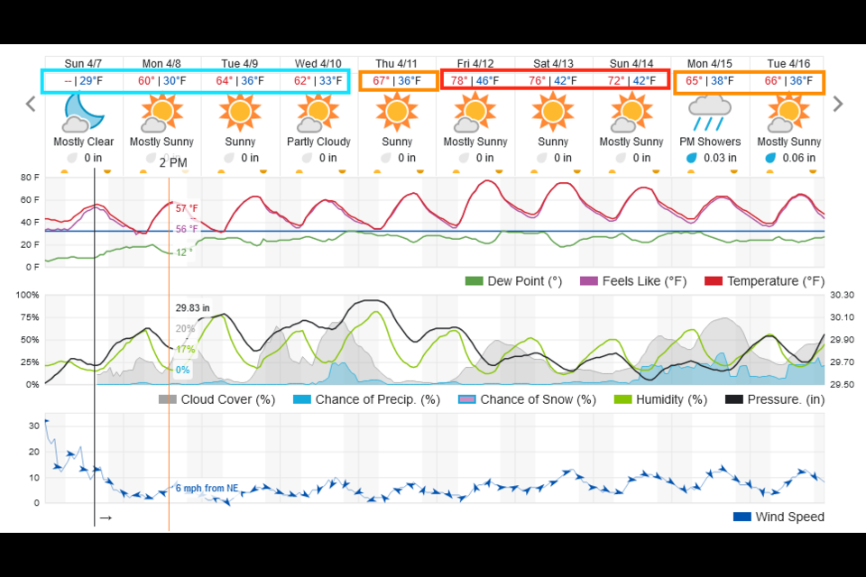
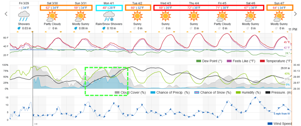
Strong winds and high fire danger continues for a few more hours. We take a few days to return to the 70's (Figure 1 update) while rain chances remain very low.

For the eclipse, the sun will be blocked to about 70% at 12:41pm.  The first moment of partial eclipse will arrive at 11:24am and the partial eclipse will end at 1:54pm.  At NO time will this eclipse be safe to view with the naked eye from Colorado. Skies will be mostly clear at the time of the eclipse (red line in Figure 1 update).

  You must have approved sun viewing glasses to view this directly (there are still some that will arrive over night and same day from Amazon (not a sponsor).  You can also view it by putting a small hole in an index card and projecting the image on another card below, or on a table surface (for example).  Be safe and enjoy!

figure1u_04072024
Caption

End Sunday update.

The Forecast Discussion:

Friday showers move off to the east as a warm weekend sets up (Figure 1).  Another somewhat-cut-off low drifts by Sunday PM and Monday giving us a possible quarter inch of rain.  Nighttime snow showers are possible, but I-25 cities may only see snow in the air or a coating on the ground overnight.

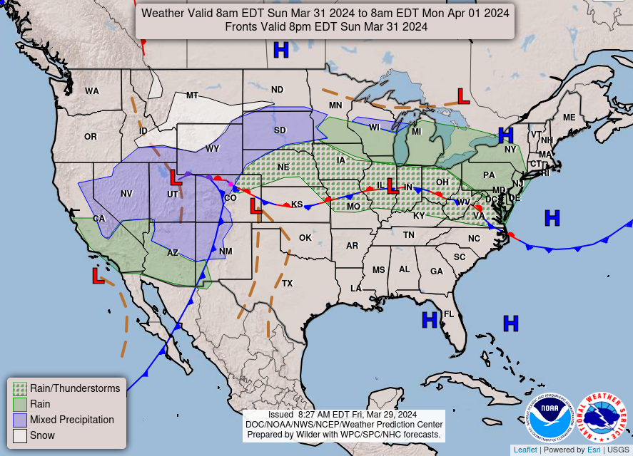
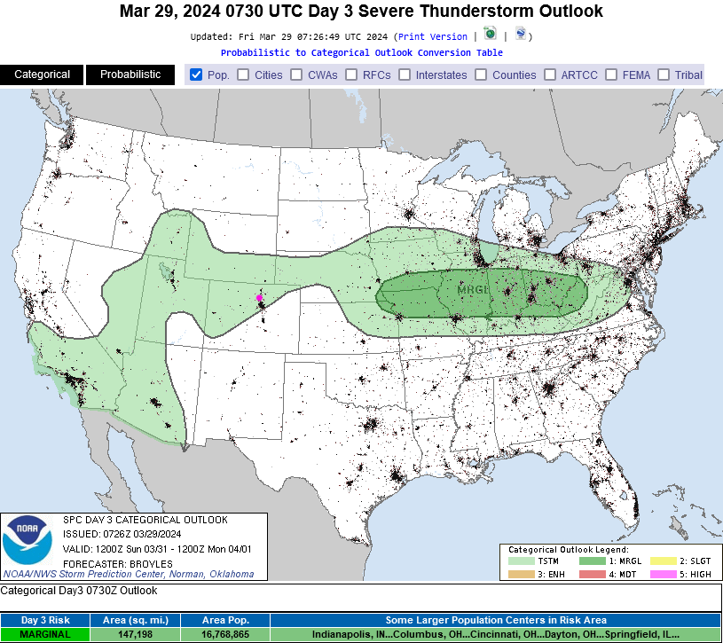
The Sunday/Monday showers come in with a low pressure system and cool front (Figure 2). There will also be a chance of thunder with this system, but nothing severe (Figure 3).

Easter Sunrise Forecast:

Sunrise will be at 6:34am with temperatures around 36F, 20% cloud cover, and winds from the easte around 4mph.  It should be a pretty good sunrise service wherever you go along I-25.

figure1_03292024
Figure 1: the 10 day graphical forecast for Longmont from weatherunderground.com
figure2_03292024
Figure 2: the Sunday surface forecast map from the NWS.
figure3_03292024
Figure 3: the SPC thunderstorm/severe weather forecast for Sunday.

The Long Range Forecast:

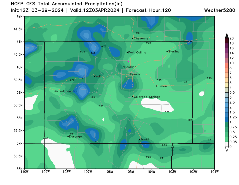
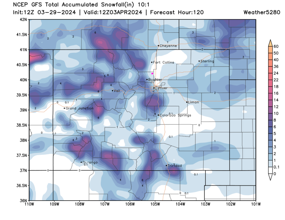
A warm-up kicks in Tuesday with possible 70's later in the week (Figure 1).  For Longmont, the next 5 days may see up to a quarter inch of water fall (Figure 4), but snowfall should remain in the Foothills and nearby mountains (Figure 5). 

figure4_03292024
Figure 4: the 5 day precipitation forecast from the GFS and weather5280.com
figure5_03292024
Figure 5: the 5 day 10:1 ratio snowfall forecast from the GFS and weather5280.com


About the Author: John Ensworth

John Ensworth used to work from Longmont as the PI for the NASA through the IGES (The Institute for Global Environmental Strategies). He now teaches technology, algebra, astronomy, meteorology, film school, and Lego robotics to middle/high school.
Read more


Comments


Current Weather

Sunny

Sunny

51°F

UV Index
1 Low
Pressure
29.98 Rising
Visibility
8 miles
Dewpoint
34 °F
Humidity
51%
Wind
NNW 2.4 mph
Gust
5.4 mph
Wind Chill
51 °F

Hourly Forecast

Today
7 AM
51°F
Mostly sunny
Today
8 AM
57°F
Mostly sunny
Today
9 AM
62°F
Mostly sunny
Today
10 AM
66°F
Mostly sunny
Today
11 AM
70°F
Mostly sunny
Today
12 PM
72°F
Mostly sunny
Today
1 PM
75°F
Mostly sunny
Today
2 PM
77°F
Mostly sunny
Today
3 PM
79°F
Mostly sunny
Today
4 PM
77°F
Mostly sunny
Today
5 PM
74°F
Partly sunny w/ t-storms
Today
6 PM
72°F
Mostly sunny

7 Day Forecast

Partly sunny w/ t-storms

Saturday

79 °F

Mostly sunny and not as warm, becoming breezy with a thunderstorm in spots this afternoon


Partly cloudy w/ t-storms

Saturday Night

49 °F

A thunderstorm in spots early this evening; otherwise, partly cloudy


Mostly sunny

Sunday

83 °F

Sunshine and patchy clouds; breezy in the afternoon


Mostly clear

Sunday Night

51 °F

Mainly clear


Intermittent clouds

Monday

70 °F

Cooler with times of sun and clouds; a thunderstorm in spots in the afternoon


Thunderstorms

Monday Night

46 °F

Cloudy; evening thundershowers followed by a couple of showers late


Mostly cloudy

Tuesday

60 °F

Mostly cloudy and cooler


Intermittent clouds

Tuesday Night

37 °F

Partly cloudy


Intermittent clouds

Wednesday

70 °F

Pleasant and warmer with intervals of clouds and sun


Mostly clear

Wednesday Night

40 °F

Mainly clear


Sunrise and Sunset

Sunrise
5:41 AM
Sunset
8:13 PM

Based on AccuWeather data